Tag Archives: river

Chamberlains, North Fork of the American

After winter, it is always a bit awkward dusting off the paddling gear and heading for the river. Arms feel like small rubberbands, and reflexes are still in hibernation. But after instinct and experience begin to recall their responsibilities, your body slowly remembers what it loves about paddling on a river.

It was quite nice to descend down from the snow covered Sierras to the beginnings of spring in Colfax. Chamberlains is a perfect class III-IV warm up to kick start the paddling season and remember what it is all about.

Here is a little off-the-couch production that depicts the first days of river recollection, hanging out with some Cali folks.

Bald Rock, Middle Fork of the Feather

There are rivers, and then there is Bald Rock Canyon on the Middle Fork of the Feather. Just north of Oroville, California, this granitic masterpiece is a close equivalent to Yosemite Valley, except for the fact that there is an extremely exciting and challenging class V river run coursing through the middle of it.

I have paddled Bald Rock at many varying levels and at different times of the year. The major obstacle to contend with is Atom Bomb Falls, and the higher the water level the harder it is to navigate the must-make ferry above it. It is the only mandatory portage, and the rest of the rapids are boatable in some form or another. Optimal flow is 1,000 cfs, but the run certainly goes quite well anywhere between 800-1500cfs.

What is unique about Bald Rock is the geologic composition. White gleaming granite walls quickly envelope you as you meander downstream into the maw. Flakes of rock and giant boulders have sloughed off the sides of the canyon and fallen into the riverbed to form rapids. If you imagine the canyon as a giant V-shape with debris falling into its middle, you can also imagine the undercuts that ensue because of this action.

Nevertheless, the majority of the rapids are good-to-go, and a solid team with good scouting and reasonable judgement can make it down unscathed.

Many paddlers opt to camp overnight at Atom Bomb Falls. It is a beautiful array of rock and sleeping spots are numerous. If you elect to do the run in one day, keep in mind that the Middle Fork of the Feather flows into Oroville Reservoir, and unless you are lucky enough to get a tow across the lake from a motorboat, you will have a 3-mile paddle out across flat water. Following that is and a steep climb up to the dirt road that serves as the take-out. It’s a long day no matter what.

 My most memorable moment on Bald Rock was a trip I did in mid-February. I was fortunate enough to have a friend, Kevin Greggerson along with his motorboat, and his girlfriend was kind enough to run shuttle for us. We were bombing down the run with me in the lead, and just as we were coming to the lip of Curtain Falls a Bald Eagle flew directly over our heads. Instead of stopping to scout, I stroked off the lip and landed comfortably at the bottom. Kevin and Andrew followed directly afterwards, and each of them had perfect lines. We were all smiles when we reached the boat and the warm clothes, beers, and smiling female faces inside.

My second most memorable trip was with Grant Korgan, and I will never forget watching him get absolutely trundled in a rapid to the point where I thought he might drown. I hate those situations in kayaking when you are in a position where you simply cannot access the person in need. Fortunately, he escaped the jaws of death, and he is still plunging into giant rapids today. The infamous rapid is halfway down the run, right above Curtain Falls, and it is marked by a giant pyramid rock at the bottom. Another friend of mine, Kells burst his ear drum in the same rapid.

As far as the combination of scenery, quality whitewater, and lack of crowds is concerned, Bald Rock is a true gem. It is logistically difficult to access, but it is definitely worth the effort. 

Fordyce Creek

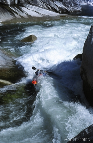
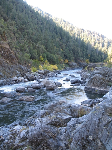
Fordyce Creek is located in the Sierras just west of Truckee, California. It is an absolute gem for its spectacular scenery and miles of uninterrupted rapids. I often feel as if I am traveling on a high alpine trail when I am kayaking Fordyce.

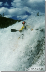
However, Fordyce is not to be taken lightly. It is fairly remote and full of surprises. I have seen a significant amount of carnage over the years, including one death as a result of a vertical pin, a deep face laceration, a fractured jaw, and several swims. Additionally, every year there are new placements of fallen trees to contend with, and these obstacles always seem to be around blind corners or hidden in tight chutes.

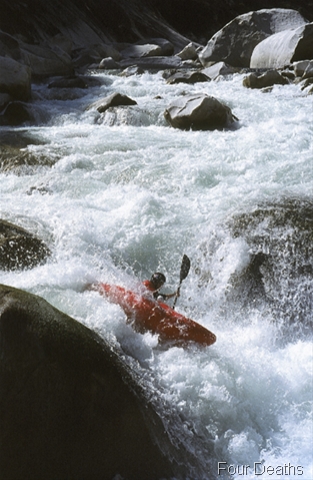
Despite these inherent dangers, Fordyce is an unforgettable experience that will leave you both satisfied and sufficiently exercised. Optimal flow is between 3-600 cfs, but it can be run as flows as low as 200cfs.

Boatable flows on Fordyce are few and far between. In my experience, the past 8 years have consisted of calling the dam keeper and asking what the flow is. Usually, there is a period of one to two weeks in the Spring when it is running, and then sometimes is the Fall it will also run as they prepare to drop the reservoir down for the winter.

Part of the problem is the area around Fordyce is a popular recreational area for OHV-4 Wheelers, and many of them like to cross the creek. Even though many of them equip their vehicles with snorkels, the creek has to be at fairly low level for them to make it across; in fact, I have seen several of them stuck in the river, attempting to wench their way out.

So come summer, the snow completely melts away, Fordyce release levels go down, and the 4-Wheelers come out. Naturally, I would like to see a compromise where whitewater enthusiasts can be guaranteed boatable flows for part of the summer, and the 4-Wheelers can have their own scheduled dates. For as it stands now, kayakers and rafters are not receiving equal consideration.

Put-in

Once you make the challenging 4-wheel drive down to the put-in, look for the water shooting out of the pipe at the bottom of the dam. If it’s not, you have just gotten screwed by the irregular releases that have historically presided over the run.

If there is water you scramble down the trail adjacent to the dam and the outflow pipe for Fordyce Lake. Look for the painted arrows at the far side of the parking area.
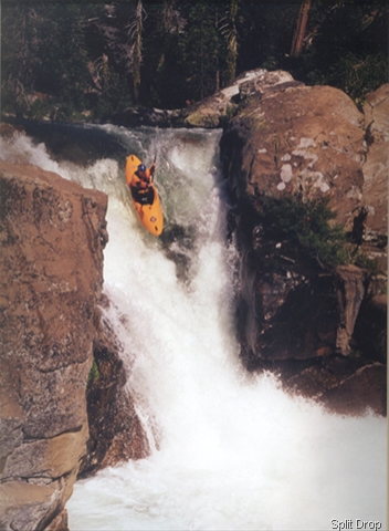
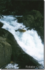
Eraserhead

As soon as you apply your first stroke forward, the day is on and you are quickly approaching the first rapid, Eraserhead. A fun 50 foot slide, Eraserhead is usually run far left or center until the bottom,where it is best to make an immediate right at the point of connecting with the bottom hole.

Portage

There are many class IV rapids between here and the portage. Although, it should be noted the portage has been run by at least two people I know of, one of which had a dicey run at best. You will know when you are getting close because you will emerge into an open hanging valley suspended above a spectacular view of Old Man Mountain. Portage right or left.

Continue reading Fordyce Creek

The Rogue River

This past weekend I journeyed northward for a long overdue trip down the Rogue River. A Tahoe contingency combined with an Oregonian posse to fly fish and float the Wild & Scenic section that starts just down the road from Galice at Grave Creek. We were fortunate to have 3 days of sunny weather complemented by beautiful fall foliage and a flow of 1250 cfs. Much bourbon was consumed, an excessive amount of shit was talked, and few fish were caught.

The Rogue is one of those classic rivers in Oregon that I have frankly always put off because there is so much to paddle in California. It is not a challenging run in terms of difficult whitewater, but it is a wonderful experience for any river enthusiast because it is filled with impressive scenery, abundant wildlife, and rich history.

If I recollect correctly, there are basically three distinct canyons with the first and third containing the only noteworthy rapids of any distinction. The first one is Rainey Falls. It contains a rather stompy hole on river left, which can easily be avoided. The second is Blossom Bar, which is generally run on the left.

I was paddling a Dagger Kingpin, which allowed me the freedom to explore interesting lines in both of these rapids. The rest of the time I sought out any play I could find.

We saw several bald eagles and deer over the course of the trip, and I had a river otter paddle by me just a few feet away. On the first day, there was an abundant amount of salmon spawning up the river, and it was fantastic to watch them leap clear out of the water around almost every bend.

The second night we camped just down from the Rogue River Ranch. It is a neat place with an old museum and several other interesting structures that were sold to the Bureau of Land Management under the Wild and Scenic Act. You can read more about it here. Suffice to say, it contains over 8,000 years of history involving both Indians and white pioneers. You may feel like a discoverer making your way down the Rogue River corridor, but the fact is many people have come before you. The Rogue has been used as source of sustenance, travel, protection, mining, and recreation for a long time.

As one who appreciates the incredible force of rivers, I will not forget the black and white photograph inside the museum that showed the Rogue at a tremendous level back in 1964. We were a great distance above the natural banks of the river, say, 100ft or more; yet, a grainy photograph showed the river coursing over the very ground we were standing on. When nature decides to kick ass, get out of the way. 

The Rogue is another example of what proper resource management can accomplish. It could be buried under a dam project or polluted to the point of no return. Instead, it is a source of revenue for local outfitters and businesses, and it allows for visitors and locals alike to experience wilderness and history unabated in a unique and preserved wilderness setting.

We must continue to preserve our rich natural heritage.