 If you are going to go sea kayaking in Tampa, Florida you better bring lots of gas, a big outboard engine, and your racing stripes. We take sea kayaking here seriously people! Personally, my paddle converts into numb chucks just in case I get pissed off, which is a lot. To get ready I generally shove cigs, cold corn beef hash, and Folgers Crystals into my craw. I then chase it all down with a Big Gulp from the 7-11. This magic combo gets me fired up to convene with nature even though I would really just prefer to shoot everything that comes near me. Also, don’t get too close. My kayak has an exploding tip, and I won’t hesitate to paddle into your’s if it suits me. You should see me coming though. I generally have my tunes playing pretty loud.
Just teasing!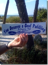
Actually, it is quite the opposite. I really like the health and stealth a sea kayak brings me. A motorboat can be a good option, but if you are looking to get into places where they can’t go, achieve a nice upper body workout, and maybe even sneak up on some fish in the flats, a sea kayak is a great way to get out and explore.
In the time I have been in the Tampa, Florida area I have managed to discover quite a few nice places to explore in a sea kayak. Many of them are within an hours drive of downtown Tampa and can easily be accomplished in a day or less. Choose from brackish rivers, saltwater estuaries and white-sand beaches; it is all up to you as to what you want to experience.
What is amazing about the state of Florida is that it pumps out an estimated 8 billion gallons of spring water on a daily basis. Percolating up through, around, and down the limestone layers that make up the state, a significant portion of this water either finds its way into Tampa Bay, or in close proximity to it. What’s more, Tampa Bay constitutes 300 square miles of open water filled with opportunities to dip a blade. There is a reason why it was such a favorite hiding place for pirates back in the day.
Here are a few sea kayaking trips around Tampa to get you started.
Weedon Island Preserve
 The Weedon Island Preserve offers a 4-mile long canoe and kayak trail that winds through mangroves, lagoons, and across open water. It takes about 3-4 hours to complete and is marked with numbered signs to help keep you from getting lost along the way. There is a Cultural and Natural History Center close to the put-in that details the life of the former inhabitants, and right across from the entrance are sea kayaks for rent in case you need one.
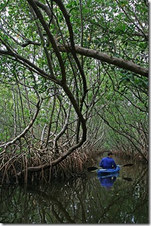
The paddling through the narrow alleyways is a great experience. Look for the countless little fiddler crabs that cling to the mangrove roots, and keep a sharp eye out for mammals crossing the passages. You will most certainly see a myriad of bird life including, herons, egrets, ospreys skimmers, spoonbills, white pelicans, and wood storks. If you are lucky you might see a bald eagle or even a manatee. There are also some hiking trails and an observation deck if you want to do some more exploring on foot.
Be sure to make your plans around the high tide; otherwise, it gets too shallow in the places you really want to see. There are some great fishing spots in the area, so you might also want to bring a rod. Finally, bring bug spray for that afternoon take out. Every time I’ve been to Weedon Island the gnats have been ferocious in the afternoon, and there is nothing more agonizing than trying to tie your kayak on the car while being molested by these little creatures.
Hillsborough River
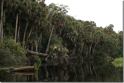
 The Hillsborough River is just northeast of downtown Tampa and offers several sections to explore by kayak. You can choose to set a shuttle to avoid retracing your steps, or paddle in and out. There is easy access at the Hillsborough River State Park, and you can ply upstream or downstream and still return with relative ease. The mix of hardwoods, palm, and cypress knees make for a beautiful combination, and it really lends itself to that feeling of “Old Florida” you so often hear about. Alligators, turtles, and birds abound, so you must be comfortable with the rustling and bustling of wildlife around each turn.
If you are fortunate enough to witness dozens of white ibis take wing over the course of the river that alone is well worth the trip. I for one was completely enamored with the beautiful reflections off of the brackish waters, the calm stillness, and the fact that hardly anyone was around even on a weekend.
If you want to mix it up you can also bring a bike with you. There is a maze of trails in the park to explore and a nice loop that equates to about 25 miles.
Myakka River
 The Myakka River State Park is about an hour south of Tampa on the outskirts of Sarasota, and it is an absolutely wonderful place to visit. It is one of Florida’s first state parks and Wild & Scenic Rivers. Even if you just want to walk or drive around it is well worth the trip, but the people that really get it bring a bike or a kayak. You have to obtain a permit if you want to paddle into the Preserve. The ranger station only gives out 30 per day, and there is no advance reservations allowed. I saw nary a soul when I went and had no trouble getting one. Even if for some reason a group grabbed all the permits you would still have plenty of worthwhile places to paddle, including the Upper Myakka Lake and the parts of the river that are not in the Preserve.
If you are looking to see alligators, this is the place. In fact, I would strongly advise never putting yourself in the position of tipping and having to swim. What is it about a thin colored piece of plastic that convinces a 2 million year old mind that you are not easily edible? At one point I was paddling around a very narrow and overgrown sluiceway when I rounded the corner and locked eyes with an alligator that was easily 12 feet in length and just a few feet away. There was a pause, and then there was an explosion as both parties hastily went their separate ways. I marveled at the raw power of the alligator and the rapidity of my heart before deciding I had experienced enough.
After successfully exiting the river, one should take time to explore the Canopy Trail and the bird walks, for there is plenty to see and experience here as well. It is these well-organized and cared-after parks that makes me take pause to appreciate what tax dollars and motivated individuals can do to protect a very valuable place. Stop by the coral monument and give thanks, and then give a high-five and a big smile to the rangers when you leave.
Anclote Key
 Anclote Key Preserve State Park is located two miles off of the coast of Tarpon Springs and approximately 45 minutes north of downtown Tampa, Florida. It is a beautiful island that features both back and open-water kayaking with abundant bird life and great fishing opportunities. The best way to sea kayak it is to launch from Fred Howard State Park and paddle straight across. It is best advised to have a spray skirt and pump in case it gets choppy, for you will cross some exposed open water and a waterway for motorboats.
There is an old abandoned lighthouse on the island that was built in the 19th century, as well as a campground if you want to stay overnight. According to the website, “these northernmost barrier islands are considered by experts to be among the top five sites in the state for diversity and numbers of beach-nesting birds.” I can tell you this, I saw a multitude of birds and more. It is absolutely beautiful out there, and you will feel like Robinson Crusoe walking down that white-sand beach. Paddling back to Fred Howard State Park I watched a a very large Tarpon launch some 4-5 ft out of the water and caught several blue fish on an artificial lure.
My suggestion: plan to have time to check out Tarpon Springs after your paddle. It is an old Greek community that has made history from the practice of diving for sponges. The town is rich with colors, sounds, and smells of the Meditteranean, and a photographers dream with the old boats, nets, and people laying about. You will certainly get an appreciation for time and place despite the town’s attention to tourism.
Fort de Soto State Park
 Emerge from the ubiquitous development and the pervasive amounts of people, cross the bridge, and boom, paradise. It would serve you well to go on a weekday, but if not, it is still worth the venture. Fort de Soto has consistently been voted as one of “America’s Best Beaches” because, well, it is.
Palms, white-sand, and blue water stretch for miles in either direction. Choose to put in a rigorous 10-mile loop, or just cruise around and catch trout and bass on the fly. Put your kayak in on the front or back side of the island, and no matter what you will have plenty of paddling options. You can even make the 2-mile trip out to Edgemont Key if you don’t mind open water. Just remember it is 2-miles back.
If and when you are done sea kayaking, you can proceed on foot and explore the old forts that are located on both Fort de Soto and Egmont Key. At one point these were major staging grounds for soldiers, but now they stand vacant in the tropical sun.
There are kayak rentals and tours out at Fort de Soto if you need them.
Honeymoon Island State Park
 This island can get quite crowded on the ocean side, but behind the island you will often see nary a soul. I like this paddle because it is a good distance for me from the causeway, just before the entrance to the park, to the far point of the island and back again. If you are feeling especially expeditious then you can paddle across the Saint Joseph Sound to the far island between Anclote and Honeymoon.
There are several stops along the way, including Pelican Cove. Bald eagles nest here along with many other shore birds. Paddling close to the mangroves you will see snook, bass, and several other tropical fish. If you paddle around the horn to the ocean side you will generally see several dolphin schooling about, for this seems to be a popular spot for them.
Also see:
Additional Resources
I highly recommend picking up a copy of John Molloy and crew’s book, “Canoeing & Kayaking Florida.” The descriptions are excellent, and there are helpful guides for running the shuttles and navigating the various nuances of Florida’s waterways.
Also, the folks at Osprey Bay Outdoors are extremely knowledgable and friendly, and they organize regularly scheduled trips all over the Tampa Bay area.
Here is a map of the locations discussed in this post:
